Along state highways in New York, reference markers are posted functioning similar to mile markers. Monroe County also has a system of reference markers, as does the neighboring state of Vermont.
New York State Reference Markers
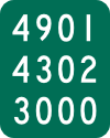
New York has a system of reference markers, similar to mile parkers, that are posted at around fifth (tenth on freeways) mile intervals along highways maintained by the state. On freeways, the markers are installed every tenth mile in addition to mile markers (regions 1, 3, 4, 5, and 8, and also the Thruway, also have tenth mile markers on some freeways). The top line is the official route number (with an I suffix for interstates and a U suffix for US 2 and US 15). The first digit of the middle line is the region number (0 for 10 and X for 11) and the second denotes the county (generally the alphabetical order within the region; note that for regions 10 and 11 this is alphabetical order between the two of them); together these form the county code. The last two digits are the number of counties the route has passed through including the current one (in NYC, only the last digit is used for this purpose, with a letter in the second to last digit - M for mainline, and C for collector/distributor). The first digit of the last line is the control segment number (denoting a segment of maintenance; for each county it starts at 1 and increments for each change in maintenance, typically at city lines; in NYC, the number instead denotes the direction of the road, with 1 representing northbound, 2 for southbound, 3 for eastbound, and 4 for westbound); the remaining digits are the distance in tenths of a mile from the county line or control segment change, whichever is closer. More information is available in the reference marker manual.

The above image shows a NYSDOT reference marker. The marker corresponds to I-490 in Monroe county leaving the city of Rochester.
Monroe County Refrence Markers
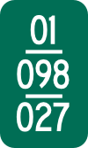
Monroe county posts reference markers at bridges and culverts on its county highways, as well as bridges on other roads the county maintains. The top line is the two digit code indicating the town. The middle line is the county route number. The bottom line is the distance in hundredths of a mile from the town line or beginning of the road.

The above image shows a Monroe county reference marker. The marker corresponds to CR 98 (Winton Road) in the town of Brighton 0.27 miles from the Henrietta town line.
Vermont Reference Markers
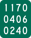
The neighboring state of Vermont also uses reference markers, which are supposed to be installed every fifth mile. The top row is the route number, with any suffix converted to a number (A = 1, B = 2, etc.) or 0 in the absence of such a suffic. The middle row has two digits for the county and two digits for the town; both go start at 01 and go up in alphabetical order of names. The bottom row is the distance in hundrdths of a mile from the town line or route beginning. On freeways, instead of reference markers, MUTCD-compliant mileposts are erected every fifth mile.

The above image shows a Vermont refernece marker. The marker corresponds to VT 117 in the town of Essex in Chittenden County 2.4 miles from the start of the route.