
The NY 17 freeway across southern New York state is composed of two sections: the Southern Tier Expressway and the Quickway. The Quickway was constructed in the 50s and 60s as a response to traffic congestion along NY 17 to the Catskills. The Southern Tier Expressway began as an extension of the Quickway in the 60s and was completed in the 90s, with the last segments to open being east of Salamenca to US 219 and the western portion of the Corning Bypass.
The freeway is designated as Corridor T of the Appalachian Development Highway System, and in 1998, was designated "High Priority Corridor 36" in the Transpontation Equity Act for the 21st Century (and later amended to include designation as Interstate 86). NY 17 west of the Chemung County line was signed at I-86 in December 1999.
Since 1999, I-86 has expanded a few times, first to NY 14 in 2004. In 2006, the section from I-81 to NY 79 was signed as I-86, creating a gap in the interstate. The western portion of I-86 was extended east to NY 352 in 2008, to Tioga County in 2013, and to NY 26 in 2024. The section from NY 17K to I-84 also appears to have intended to be signed as I-86, but still requires further upgrades. At this time, the designated section of the Southern Tier Expressway is considered to be I-86 alone, with NY 17 signed to ease the traveling public into the new number. Newer signs along this section only show I-86.
The estimated completion date of the upgrade, originally 2009, has been pushed back several times. Around 2010, due to lack of economic development along the parts of the corridor signed as I-86 and the state funding situation, the project was postponed indefinately, and the funding transferred to other projects. Currently, efforts are underway primarily in Sullivan and Orange Counties.
NYSDOT has a website for the upgrades. Potential interchange reconfigurations are available from the PEL study and the project scoping report for the Mobility and Access Improvements Project.


The above images use map data from OpenStreetMap (taken in January 2024), available under the Open Database License. The upgrade data is derived from the boards for the May 2024 scoping meeting on the Mobility and Access Improvements Project.
Completed/Current Projects
- Removal of at-grade intersections between exits 49 and 51; construction of exit 50
- "Horseheads Bypass" constructing new elevated mainline through Horseheads with the existing roadway turned into frontage roads accessible via new exit 53
- Reconstruction of former exits 56 and 57 into current exit 56
- Construction of former exit 58 (current exit 57)
- Removal of at-grade intersections between exits 56 and 59 and construction of current exit 58
- Minor interchange improvements (such as lengthening acceleration/deceleration lanes) for exits 62-66
- Reconstruction of the I-81 interchange/Kamikaze Curve (Phase I)
- Reconstruction of the I-81 interchange/Kamikaze Curve (Phase II) and I-81 exit 4
- Removal of at-grade intersections east of I-81 and construction of exit 76
- Interchange improvements to exits 94-97 and 99
- Removal of at-grade intersections nears Parksville and construction of exit 98
- Upgrade of deficient features around exit 105
- Reconstruction of exit 106
- Reconstruction of the bridge carrying NY 17 over the Neversink River
- Reconstruction of NY 17 between NY 17K and I-84
- Reconstruction of exit 122 (Phase I)
- Reconstruction of exit 122 (Phase II)
- Replacement of exit 125
- Upgrade east of exit 130A/Reconstruction of exit 131
Estimated Remaining Work
- Upgrade of deficient features between Tioga County and the Binghamton city line
- Upgrade of deficient features between exits 79 and 84
- Removal of at-grade intersections in Hale Eddy and construction of exits 85 and 86
- Interchange improvements to exits 87-93
- Interchange improvements to exits 100A, 100, and 101
- Interchange improvements to exits 102-104 and 107-108
- Interchange improvements to exits 109-112 and 114-115
- Reconstruction of exit 120
- Upgrade of deficient features between exits 122A-126
- Upgrade of deficient features between exits 126-130A
- Upgrade of deficient features at exits 127 and 128
- Upgrade of deficient features around exits 129 and 130
Conversion History
The images below have been obtained from the U.S. Geological Survey (USGS) Eros Archive and Google Earth.


The at-grade interchanges around Kahler Road east of Corning were removed in 2004, resulting in the creation of an interchange for exit 50. The images above are from 1995 (top, Google/U.S. Geological Survey) and 2016 (bottom, Google).


The at-grade road through Horseheads was replaced with an elevated highway in 2007, resulting in the creation of an interchange for exit 53 and removing the last traffic lights on the Southern Tier Expressway. The images above are from 2002 (top, Google/New York GIS) and 2016 (bottom, Google).


The original exits 56 and 57 in Elmira were combined into a single exit 56 in the early 2000s. The images above are from 1994 (top, Google/U.S. Geological Survey) and 2021 (bottom, Google).


The at-grade intersection in Lowman was upgraded to an interchange (originally exit 58, later changed to exit 57) in the early 2000s. The images above are from 1994 (top, Google/U.S. Geological Survey) and 2016 (bottom, Google).


The at-grade intersections east and west of Lowman were removed in 2012 and a new interchange was opened to provide access. The images above are from 2008 (top, Google/USDA/FPAC/GEO) and 2016 (bottom, Google).


The western junction with I-81 in Binghamton, known as Kamikaze Curve, was rebuilt in the 2010s, including the reconfiguration of the cloverleaf at exit 4 on I-81. The images above are from 2006 (top, Google/USDA/FPAC/GEO) and 2022 (bottom, Google).


The at-grade intersections east of Binghamton were removed in 2006, resulting in the creation of interchanges for exits 76 and 77. The images above are from 1994 (top, Google/U.S. Geological Survey) and 2011 (bottom, Google).


The last traffic light on the Quickway was removed in 2012 with the opening of the Parksville Bypass and the upgrade of exit 98 to an interchange. The images above are from 2008 (top, Google/USDA/FPAC/GEO) and 2016 (bottom, Google).

The cloverleaf with NY 42 was changed into a diamond interchange with roundabouts with the replacement of the bridge over NY 17 in 2024. The image above is from 2012 (Google).


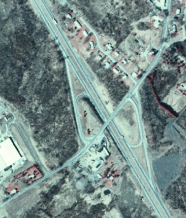
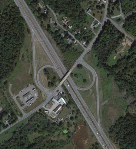
Exit 106 was upgraded into a full interchange in the early 2010s. The images above are from 2008 (top, Google/USDA/FPAC/GEO) and 2016 (bottom, Google).
Exit 119 was modernized as part of the project to reconstruct NY 17 around Middletown. The images above are from 1984 (top, USGS) and 2019 (bottom, Google).


The eastbound ramps of exit 122 were improved to interstate standards in 2015. Construction to improve the westbound ramps to interstate standards began in 2025. The images above are from 2011 (top, Google) and 2019 (bottom, Google).


Exit 125 was relocated in 2020 with the opening of Legoland. The images above are from 2013 (top, Google) and 2023 (bottom, Google).


Exit 131 was upgraded to a diverging diamond interchange in 2019. The images above are from 2013 (top, Google) and 2022 (bottom, Google).