The Mohawk Valley has a rich history of how its system of freeways and arterials has evolved over the decades. It has one interstate, I-790, which connects the Thruway to the North-South Artieral (NY 5, NY 8, and NY 12), the primary route through Utica. There is also NY 49, the Utica/Rome Expressway, which connects I-790 and the North-South Arterial to Rome, as well as other connectors such as NY 840. Amsterdam also has its own arterial system, which has evolved over the years.
The images below have been obtained from the U.S. Geological Survey (USGS) Eros Archive and Google Earth.
Contents
- Interstate 790/North-South Arterial
- NY 5 (Amsterdam)
- NY 5S/Oriskany Street
- NY 49/Utica-Rome Expressway
- NY 365
- NY 825/Griffiss Access Road
- NY 840/Judd Road Expressway
- The Marcy-SUNY Parkway
Interstate 790/North-South Arterial


I-790, when first constructed, was aligned on a two-lane connector from the Thruway to the North-South Arterial, with NY 5 on a two-lane alignment to the north of the Thruway. In the 1980s, this area was reconfigured with the construction of the modern interchange with the North-South Arterial, and the two-lane alignments were merged into a single four-lane alignment flanking the Thruway. This cut off direct access from the Thruway to I-790, requiring the use of local streets, although direct access from I-790 to the Thruway remains. The images above are from 1985 (top, USGS) and 2015 (bottom, Google).

The Thruway interchange itself was originally just with Genesee Street the former alignment of NY 5, NY 8, and NY 12 prior to the construction of the North-South Arterial. The image above is from 1958 (USGS). The interchange is currently being studied for further reconfiguration. A presentation about this study, including concepts, was given at the 2025 NYSAMPO Conference.


The North-South Arterial carries NY 5, NY 8, and NY 12. It has seen its own changes. The interchange with NY 5S was reconfigured into a more modern design in the 1980s or early 1990s and the Arterial was realigned onto a new viaduct and three at-grade intersections removed in the 2010s with the construction of the Court Street interchange and pedestrian bridge near Sunset Avenue. The Burrstone Road interchange was also reconfigured to remove the cloverleaf features. The images above are from 1981 (top, USGS), 2011 (middle, Google), and 2023 (bottom, Google).
NY 5 (Amsterdam)
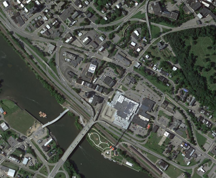
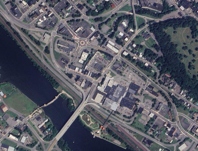
The NY 5 arterial through the Amsterdam area has recently been modified to allow for two-way traffic on the westbound alignment of NY 5, in preparation for a potential project which would remove the eastbound alignment to create space for development. The images above are from 2015 (top, Google) and 2024 (bottom, Google/Airbus).
NY 5S/Oriskany Street


The East-West Arterial (NY 5S/Oriskany Street) was reconfigured in the early 2020s to modernize and improve transportation accessibility in downtown Utica. The images above are from 2016 (top, Google) and 2024 (bottom, Google/Airbus).
NY 49/Utica-Rome Expressway
The portion of the Utica-Rome Expressway (NY 49) from NY 291 to CR 34 (Edic Road/the Marcy-SUNY Parkway) was the last to be constructed, with a project in the early 2000s finally providing a four-lane freeway that flanks the Thruway for much of its length. Prior to then, traffic had to use River Road.


The interchange with NY 291 was a cloverleaf with the expressway feeding directly into River Road prior to the construction of the current alignment of NY 49. The images above are from 1997 (top, Google/U.S. Geological Survey) and 2015 (bottom, Google).


The interchange with CR 34 was likewise reconfigured to increase the merging distance when the Expressway was completed. The images above are from 1997 (top, Google/U.S. Geological Survey) and 2015 (bottom, Google).
NY 365


The NY 365 expressway continues the freeway for the Utica-Rome Expressway westward back to the Thruway in Verona. The area around NY 26 and James Street was upgraded in the early 2020s to improve safety around those two intersections, essentially creating an extension of the freeway. The images above are from 2015 (top, Google/Airbus) and 2025 (bottom, Google/Airbus).
NY 825/Griffiss Access Road


The Griffiss Access Road (NY 825) was constructed in the early 2000s and upgraded in the late 2010s to improve access around Griffiss Airport and the Griffiss Technology Park after the area ceased to be a military base. The images above are from 1997 (top, Google/Maxar Technologies), 2015 (middle, Google), and 2020 (bottom, Google/CNES/Airbus).
NY 840/Judd Road Expressway


The Judd Road Expressway (NY 840) was constructed in the early 2010s to improve transportation access through New Hartford and connect Judd Road to the North-South Arterial. The images above are from 1997 (top, Google/U.S. Geological Survey) and 2015 (bottom, Google).
The Marcy-SUNY Parkway


Connecting to the Utica-Rome Expressway, CR 34 was realigned from Edic Road onto the Marcy-SUNY Parkway (briefly known as the Marcy-SUNYIT Parkway) in the early 2010s. The connections to the Nanotech facilities were completed in the early 2020s. The images above are from 2008 (top, Google/U.S. Geological Survey), 2015 (middle, Google), and 2024 (bottom, Google/Airbus).