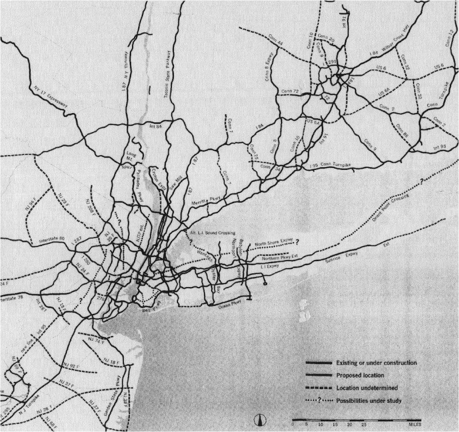
The Mid-Hudson Region includes the northern suburbs of New York City, and as such, the freeway system is oriented around NYC. There are a few cancelled corridors, including an extension of the Croton Expressway and an extension of the New Jersey Turnpike. The image above is from a 1964 report developed by the Tri-State Transportation Comission and published in the May 1964 edition of Regional Plan Association News, available on Steve Anderson's NYCRoads.com.
The system has seen significant evolution, especially considering that many of the parkways, such as the Taconic State Parkway, were built before modern freeway standards and were upgraded after their initial construction. It has also seen activity related to upgrading NY 17 to I-86, which is depicted in its own article. The images below have been obtained from the U.S. Geological Survey (USGS) Eros Archive and Google Earth.
Contents
- Interstate 84
- Interstate 87/New York State Thruway
- Interstate 287/Cross-Westchester Expressway
- Interstate 587/Colonel Chandler Drive
- NY 17/Quickway
- Cross County Parkway
- Hutchinson River Parkway
- Saw Mill River Parkway
- Taconic State Parkway
Interstate 84


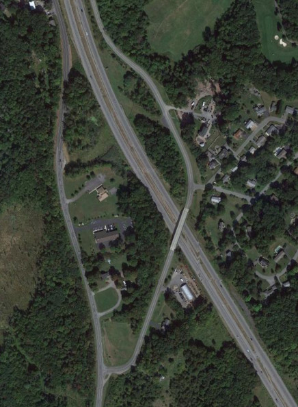
The Thruway interchange with I-84 is interesting in that it was not built with a direct connection; instead, the original interchange was retained, and traffic had to utilize NY 300 to connect between the two. The roadgeek term for this lack of a freeway/freeway connection is "Breezewood", after the town in Pennsylvania where I-70 was built withhout a direct freeway/freeway connection to the Pennsylvania Turnpike (I-76), which is overlaps with west of there, forcing traffic to utilize a piece of US 30 to stay on I-70. The images above are from 1958 (top, USGS) and 1968 (bottom, USGS).


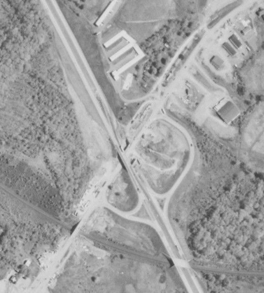
After the intial construction, the I-84 interchange with NY 300 was modified into a full cloverleaf, and the half diamond with NY 52 was made into a full diamond. The Breezewood connection was finally eliminated in 2009 with the construction of the modern interchange. Interestingly, the modern interchange was built around the same time the Thruway Authority handed I-84 back to NYSDOT in exchange for removing tolls on I-190 approaching downtown Buffalo. The images above are from 1985 (top, USGS) and 2019 (bottom, Google).


The interchange with US 9W and NY 32 was originally a diamond before being modified into its present configuration. Also visible is the right of way where an interchange with a never-built arterial highway was intended to be; this would have been exit 9 under the original sequential exit numbers, which is why there was a gap between exits 8 and 10. The images above are from 1985 (top, USGS) and 2019 (bottom, Google).


The interchange with US 9 was originally a diamond before being modified into its present configuration as development in the area increased. Evidence of the original diamond is still visible with the ramps on the eastern side of the interchange. The images above are from 1995 (top, Google/U.S. Geological Survey) and 2019 (bottom, Google).
Interstate 87/New York State Thruway


The interchange with US 9 and NY 119 in Tarrytown was modified to add an additional on ramp from NY 119 and also with respect to tolling, first to go to one-way tolls and then again with the switch to all-electronic tolling during the replacement of the Tappan Zee Bridge. The images above are from 1958 (top, USGS), 2014 (middle, Google), and 2020 (bottom, Google).


The interchange with US 9W in South Nyack was originally built with a stub to the south for a potential extension of the New Jersey Turnpike which was never built. The stub was eventually removed, and the interchange was reconfigured as part of the project to replace the Tappan Zee Bridge. The images above are from 1958 (top, USGS), 2015 (middle, Google), and 2022 (bottom, Google).


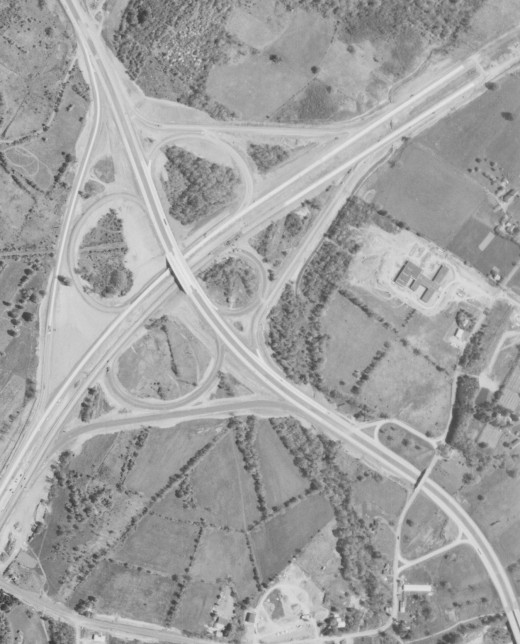
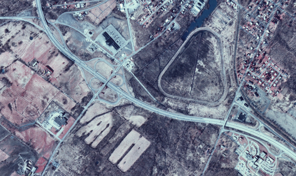
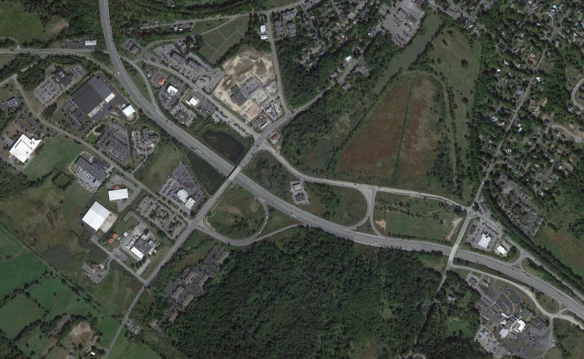
Exit 15 was extensively modified when the northern section of I-287 in New Jersey was built. The interchange was originally a trumpet with NY 17 and NJ 17 and part of the ticket system, which originally ended at Spring Valley near exit 14A instead of Woodbury at exit 16. When I-287 was built, it shifted to its modern configuration, and exit 15A was built to retain local access to/from NY 17. The images above are from 1974 (top, USGS) and 2014 (bottom, Google).
Interstate 287/Cross-Westchester Expressway


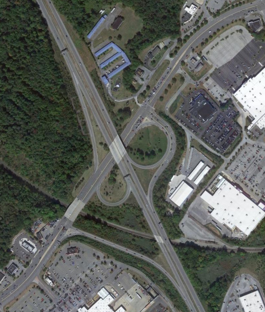
Exit 8 of the Thruway originally connected to NY 119 before I-287 was built to connect to it. Around the same time, exit 7A was built to preserve access to the Saw Mill River Parkway to/from the south. Later, the area was modified to reduce weaving and provide a high-speed mainline on I-287, with the original southbound exit 8 being used to preserve local access to NY 119 and the Saw Mill River Parkway as exit 8A. The images above are from 1958 (top, USGS), 1994 (middle, Google/U.S. Geological Survey), and 2018 (bottom, Google).


The interchange ramps around the Central Westchester Parkway and Westchester Avenue (former NY 119) in White Plains have been reconfigured, which reduced weaving on I-287. The images above are from 1974 (top, USGS) and 2016 (bottom, Google).


The interchange ramps involving US 1 where I-287 meets I-95 (the New England Thruway) have been modified from their original configuration, eliminating the area where multiple traffic streams all merge into I-95 south all at once. The images above are from 1974 (top, USGS) and 2016 (bottom, Google).
Interstate 587/Colonel Chandler Drive


Prior to the construction of I-587, NY 28 followed Washington Avenue into Kingston. I-587 was bult to bypass this section of NY 28 and connected to the Thruway at a traffic circle. The images above are from 1958 (top, USGS) and 1994 (bottom, Google/U.S. Geological Survey).


The traffic circle with the Thruway was later repalaced with a roundabout. More recently, the traffic light with NY 32 was also replaced with a roundabout, making I-587 end at roundabouts at both ends. The images above are from 2013 (top, Google) and 2023 (bottom, Google/Airbus).
NY 17/Quickway
Exit 117 on NY 17 was for Tarbell Road; the ramp and underpass were removed in 1995. The images above are from 1984 (top, USGS) and 2019 (bottom, Google).
Like exit 117, exit 118A was removed in 1995. It was the western terminus of NY 17M, which is now signed as ending at the intersection with Sands Road. The images above are from 1984 (top, USGS) and 2019 (bottom, Google).
The interchange with NY 211 was modified in the early 1970s. The images above are from 1968 (top, USGS) and 2019 (bottom, Google).

The interchange with CR 67 was also modified from its original version, and has been modified since for the I-86 upgrade. The images above are from 1968 (top, USGS) and 2011 (bottom, Google).
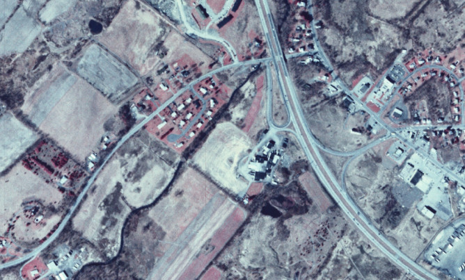
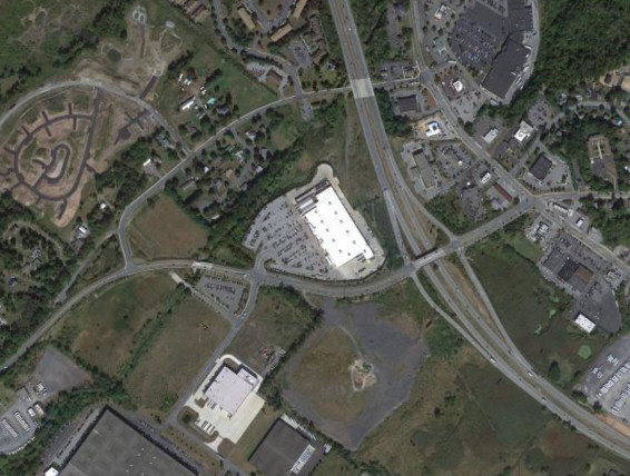
The cloverleaf interchange with NY 17A was modified around 1994 and the interchange to the east with NY 17M relocated in 2020 when Legoland opened. The images above are from 1984 (top, USGS) and 2019 (bottom, Google).
The interchange with NY 94 was relocated when the direct alignment of NY 94 through Chester was constructed, eliminating the overlap with NY 17M. The images above are from 1984 (top, USGS) and 2019 (bottom, Google).
Cross County Parkway


The western end of the Cross County Parkway and the interchange with the Saw Mill River Parkway were modified as the parkways were modernized. The images above are from 1959 (top, USGS) and 2016 (bottom, Google).


The modernization of the Cross County Parkway included the development of express and local lanes around the Thruway and the Bronx River Parkway. The images above are from 1959 (top, USGS) and 2016 (bottom, Google).


The eastern end of the Cross County Parkway at the Hutchinson River Parkway was also modified as the parkways were modernized, making the Cross County Parkway the thru movement and turning it into a half interchange. The images above are from 1959 (top, USGS) and 2016 (bottom, Google).
Hutchinson River Parkway


The interchange with NY 127 was modified as the parkway was modernized, as was the nearby Marmaroneck River Service Area, becoming a centralized gas station in the median rather than being separate facilities on each side. The images above are from 1974 (top, USGS) and 2016 (bottom, Google).


The area where the Hutchinson River Parkway meets I-287 was extensively modified with the addition of I-684, the modification of the NY 120 interchange, and the addition of the Manhattanville Road interchange. The images above are from 1959 (top, USGS), 1974 (middle, USGS), and 2016 (bottom, Google).
Saw Mill River Parkway


The northbound access at the Croton Avenue interchagne was removed, likely because it led into a residential neighborhood. The images above are from 1959 (top, USGS) and 2018 (bottom, Google).


The northern end of the Saw Mill River Parkway was extensively modified when I-684 was built, making it end at I-684 rather than connecting to NY 22 directly. There was also extensive modification to routes such as NY 35 and NY 117. The images above are from 1959 (top, USGS) and 2018 (bottom, Google).
Taconic State Parkway


The Taconic State Parkway was very extensively modified when it was modernized in Westchester County, particulary where it met the Saw Mill River Parkway at what was once a traffic circle and is now half a stack interchange. The area was also modified with the construction of the Sprain Brook Parkway and the interchange with NY 117. The images above are from 1958 (top, USGS) and 2018 (bottom, Google).


The parkway was extensively moddified around NY 9A, NY 117, and Pleasantville Road. The images above are from 1958 (top, USGS) and 2018 (bottom, Google).


The area around the New Croton Reservoir also saw extensive modification. The original bridge was used for the northbound lanes while a new bridge was constructed for the southbound lanes. NY 129 now crosses the parkway without intersecting it and there is a diamond interchange with Underhill Avenue. The images above are from 1958 (top, USGS) and 2018 (bottom, Google).


The modernization of the parkway saw the construction of an intercahnge for Franklin D. Roosevelt State Park and improvemetns to the interchanges with US 202 and NY 35 as well as the eastern section of the Bear Mountain State Parkway. The images above are from 1958 (top, USGS) and 2018 (bottom, Google).


The interchanges with NY 132 and US 6 near the northern border of Westchester County were modified as well. The images above are from 1958 (top, USGS) and 2016 (bottom, Google).


A more recent upgrade is the replacement of the at-grade intersection at Pudding Street with an interchange. The images above are from 2016 (top, Google) and 2023 (bottom, Google).